Key Points:
- Erin formed near Cabo Verde and may become 2025’s first hurricane.
- It could reach Category 3 and affect the Caribbean to eastern North America.
- Officials urge readiness as Erin has caused deaths and may intensify quickly.
Erin Hurricane began as a tropical storm on Monday, August 11, 2025, in the eastern Atlantic, just west of the Cabo Verde Islands. It is the fifth named storm of the ongoing Atlantic hurricane season, which runs from June 1 to November 30. At the time of its formation, Erin carried maximum sustained winds of around 45 mph and was moving westward at nearly 20 mph.
Meteorologists quickly identified its potential for intensification, with forecasts suggesting that Erin could strengthen into a Erin Hurricane within days. Favorable atmospheric conditions and warm sea-surface temperatures are expected to fuel its growth as it travels across the Atlantic this week.
Forecasted Path and Intensification
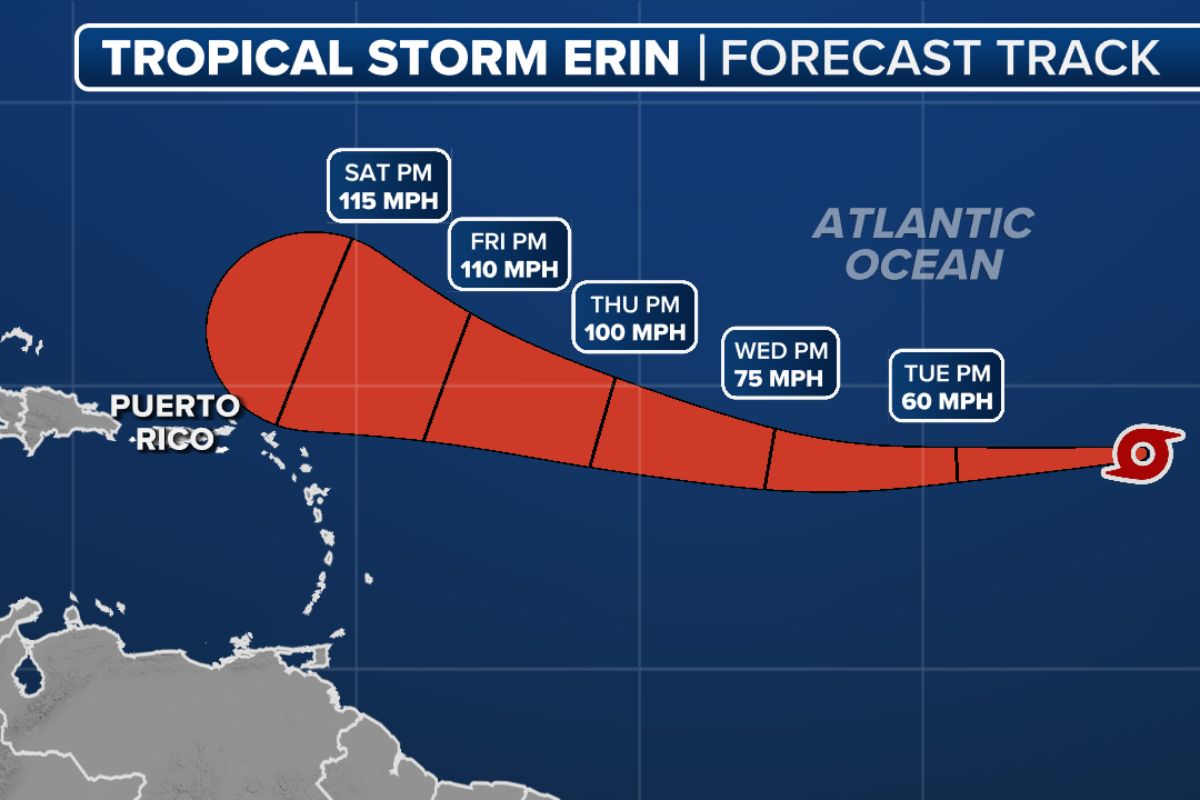
Forecast models project that Erin will steadily strengthen, potentially reaching Erin Hurricane status by midweek and becoming a major Category 3 hurricane by the weekend. Its track is currently expected to pass north of the Lesser Antilles, though the precise timing and angle of a possible northward turn remain uncertain.
Two key scenarios are being considered. If Erin intensifies rapidly, it could curve northward into the open western Atlantic, potentially influencing weather systems near Bermuda. However, slower strengthening might keep it on a more southerly course, bringing it closer to the Leeward Islands, the Bahamas, and possibly even the eastern U.S. or eastern Canada in the longer term.
Warmer-than-usual waters in the western Atlantic due to a marine heat wave raise the risk of faster and more significant intensification once Erin reaches that region. While early indications point to a low chance of direct landfall along the U.S. East Coast, forecasters emphasize that it is too early to rule out any track changes.
Potential Risks and Preparedness
Though Erin Hurricane is still far from land, it has already been linked to dangerous conditions in the Cabo Verde Islands, where heavy rains and strong winds caused several fatalities. As it advances westward, authorities in parts of the Caribbean and coastal regions of North America are advising residents to stay alert.
The storm’s future impacts will depend heavily on its exact path and strength in the coming days. Emergency management agencies recommend that communities in potentially affected areas prepare now, securing property, stocking essential supplies, and reviewing evacuation plans.
With the peak of the Atlantic hurricane season approaching, Erin serves as a reminder of how quickly storms can develop and intensify. Residents are urged to follow official weather updates closely, as forecast models may shift significantly over the next week.
Visit Visionary CIOs for the most recent information.